The Ocean Vector Chart Service (OVCS): Revolutionizing Submarine Cable Route Planning
Introduction to OVCS
Makai Ocean Engineering and Triton Software Ltd have collaborated to introduce the innovative Ocean Vector Chart Service (OVCS), integrating high-resolution nautical charts directly into MakaiPlan, a leading submarine cable route planning software. This partnership enhances navigation accuracy and efficiency by leveraging Triton Software’s API and hosted server for Lloyd’s Register’s worldwide vector dataset.
Unlike traditional Admiralty raster charts, the OVCS feature empowers users with enhanced resolution, detail, and precision, allowing them to interrogate individual objects within the charts to view their attributes. This dynamic charting solution complements MakaiPlan by improving data accessibility and clarity during planning.
Key enhancements provided by OVCS include:
- Dynamic Charting Detail: Adjusts the level of detail based on the zoom level, allowing planners to view both broad overviews and critical, location-specific information easily.
- Lloyd’s Register Vector Dataset: Provides comprehensive global coverage, enabling confident planning across various regions and scales.
- Interactive Object Analysis: Users can interrogate chart objects to view their attributes, improving situational awareness and decision-making.
- Simplified Workflow: Eliminates the need for external charting tools by integrating all critical navigational data within MakaiPlan, reducing planning time and effort.
The installation of submarine cables is technically demanding, requiring precise planning to ensure safety and cost-effectiveness. OVCS adds value by improving the efficiency of loading and interacting with data, making it easier for planners to:
- Reduce risks associated with cable routing and installation.
- Improve efficiency by centralizing essential data within MakaiPlan.
- Make more confident and informed decisions with real-time access to detailed marine information.
This collaboration underscores the significance of OVCS in the submarine cable route planning industry, enhancing precision and efficiency Marine Technology News.
Benefits of OVCS
The integration of the Ocean Vector Chart Service (OVCS) with MakaiPlan represents a significant advancement in submarine cable route planning. This chapter delves into the key benefits of OVCS, highlighting how it improves the accuracy, efficiency, and situational awareness of cable route planning.
Enhanced Resolution and Detail
One of the most notable benefits of OVCS is the enhanced resolution and detail it provides. Traditional Admiralty raster charts often lack the precision required for detailed cable route planning. In contrast, OVCS offers high-resolution nautical charts that are web-hosted and accessible directly within MakaiPlan. This integration ensures that users can view charts with unprecedented clarity and detail, making it easier to identify and avoid obstacles such as reefs, underwater canyons, and other submerged features.
The high-resolution charts provided by OVCS are particularly beneficial in areas with complex underwater topography. By offering detailed bathymetric data, OVCS enables planners to make more informed decisions about cable routing, ensuring that cables are laid in the safest and most cost-effective manner. This level of detail is crucial for avoiding potential hazards and minimizing the risk of cable damage during installation.
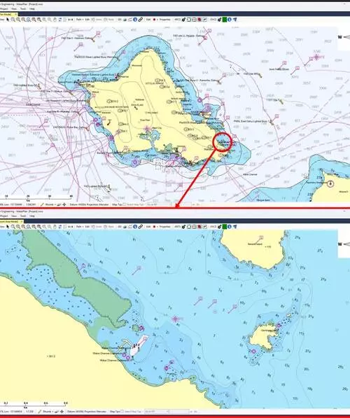
Dynamic Charting Detail
Unlike static charts, OVCS dynamically adjusts the level of detail based on the zoom level. This feature is particularly useful for planners who need to switch between broad overviews and critical, location-specific information. At a high zoom level, OVCS can display detailed information about individual objects within the chart, such as depth contours, buoys, and seabed features. Conversely, at a lower zoom level, OVCS provides a broader overview of the area, allowing planners to identify potential routes and obstacles at a glance.
This dynamic charting detail is a significant improvement over traditional charts, which often require users to switch between multiple charts or tools to access different levels of detail. OVCS eliminates this need by integrating all critical navigational data within MakaiPlan, reducing planning time and effort. Planners can now focus on making informed decisions based on real-time data, rather than spending time navigating through different charts and tools.
Interactive Object Analysis
Another key benefit of OVCS is its interactive object analysis feature. Users can interrogate individual objects within the charts to view their attributes, such as depth, object type, and other relevant information. This feature improves situational awareness and decision-making by providing users with immediate access to detailed information about the objects they encounter during planning.
For example, planners can click on a buoy to view its attributes, such as its position, type, and any associated warnings or restrictions. This information is crucial for ensuring that cables are routed safely and in compliance with local regulations. By providing immediate access to detailed information, OVCS enables planners to make more confident and informed decisions, reducing the risk of errors and improving the overall efficiency of the planning process.
Simplified Workflow
OVCS also simplifies the workflow for cable route planning by eliminating the need for external charting tools. By integrating all critical navigational data within MakaiPlan, OVCS reduces the number of steps required to access and interact with chart data. This simplification improves efficiency and reduces the risk of errors, as planners no longer need to switch between multiple tools and platforms to access the information they need.
Moreover, OVCS complements Makai’s existing software suite, which already provides robust tools for analyzing bathymetry, avoiding obstacles, and optimizing cable routes. By offering an advanced charting solution that improves data accessibility and clarity, OVCS enhances the overall capabilities of MakaiPlan, making it an even more powerful tool for cable route planning.
Real-Time Access to Detailed Marine Information
The installation of submarine cables is a technically demanding process that requires precise planning to ensure cables are installed safely and cost-effectively. OVCS adds value to this process by improving how efficiently planners can automatically load and interact with data. The enhanced charting capabilities of OVCS make it easier for planners to:
- Reduce risks associated with cable routing and installation.
- Improve efficiency by centralizing essential data within MakaiPlan.
- Make more confident and informed decisions with real-time access to detailed marine information.
By providing users with high-resolution charts, dynamic charting detail, and interactive object analysis, OVCS revolutionizes submarine cable route planning. This innovative service empowers users to make more informed decisions, reduce risks, and improve efficiency, ultimately leading to safer and more cost-effective cable installations.
The integration of OVCS with MakaiPlan is a testament to the power of advanced charting solutions in enhancing the capabilities of cable route planning software. As the demand for reliable and efficient submarine cable installations continues to grow, OVCS is poised to become an essential tool for planners, helping to ensure that cables are laid in the most effective and safe manner possible.
Key Features
The Ocean Vector Chart Service (OVCS) stands as a pioneering tool in digital maritime navigation, offering a suite of advanced features that enhance the accuracy and utility of electronic navigational charts. This chapter explores the key features of OVCS, highlighting its integration with Lloyd’s Register’s vector dataset, its seamless compatibility with Triton Software’s API and server, and its provision of real-time marine information.
Access to Lloyd’s Register’s Vector Dataset
OVCS integrates seamlessly with the comprehensive vector dataset provided by Lloyd’s Register. This integration ensures that users have access to detailed and up-to-date information on marine features, including depth contours, underwater obstacles, and navigational hazards. The vector dataset is not static but is continuously updated to reflect the latest changes in the marine environment. This real-time data ensures that navigators have the most accurate and current information available, thereby enhancing safety and efficiency at sea.
Integration with Triton Software’s API and Server
One of the standout features of OVCS is its integration with Triton Software’s API and server. This integration allows for a seamless flow of data between the chart service and various navigational systems, ensuring that users can access and utilize the charts in real-time. The API facilitates the transfer of data, while the server handles the storage and processing of information. This integration is crucial for ensuring that OVCS can be used effectively on a wide range of vessels, from small boats to large commercial ships. The compatibility with Triton Software’s systems guarantees that OVCS can be implemented without the need for extensive modifications to existing navigational equipment, thereby reducing costs and streamlining the adoption process.
Real-Time Access to Detailed Marine Information
OVCS provides users with real-time access to detailed marine information, which is a critical feature for modern maritime navigation. This real-time capability is achieved through the continuous updating of the vector dataset and the integration with Triton Software’s systems. Users can access information on tides, currents, weather conditions, and other environmental factors that can impact navigation. This real-time data is presented in a user-friendly format, allowing navigators to make informed decisions and avoid potential hazards. The real-time aspect of OVCS is particularly valuable in dynamic maritime environments, where conditions can change rapidly.
Dynamic Charting Detail
Unlike traditional static charts, OVCS offers dynamic charting detail that adjusts based on the zoom level. This feature is particularly useful for navigators who need to view charts at different scales. When zoomed out, the chart provides an overview of the entire area, highlighting major features and routes. As the user zooms in, the chart displays increasingly detailed information, including smaller navigational hazards and local features. This dynamic adjustment ensures that users have the level of detail they need at any given moment, whether they are planning a long voyage or navigating through a congested harbor.
Interactive Object Analysis
OVCS includes an interactive object analysis feature that allows users to interrogate individual objects within the charts. This feature enables users to click on specific objects, such as buoys, rocks, or other navigational aids, and obtain detailed information about them. The interactive analysis can provide data on the object’s position, type, and any relevant warnings or notices. This feature is particularly useful for identifying and avoiding potential hazards, as well as for planning routes that avoid known obstacles.
Compatibility and Scalability
OVCS is designed to be compatible with a wide range of navigational systems and devices, ensuring that it can be easily integrated into existing maritime infrastructure. This compatibility is achieved through the use of industry-standard formats and protocols, which guarantee interoperability with various ECDIS (Electronic Chart Display and Information Systems) and other navigational equipment. The scalability of OVCS allows it to be used on vessels of all sizes, from small yachts to large commercial ships, making it a versatile tool for the maritime industry.
User-Friendly Interface
OVCS is known for its user-friendly interface, which is designed to be intuitive and easy to navigate. The interface is designed to be accessible to users of all skill levels, from experienced mariners to those who are new to electronic navigation. The interface includes clear and concise menus, as well as interactive tools that allow users to customize their chart display. This user-friendly design ensures that OVCS can be easily adopted and used by a wide range of users, thereby enhancing its overall utility.
Conclusion
The Ocean Vector Chart Service (OVCS) represents a significant advancement in digital maritime navigation, offering a range of advanced features that enhance the accuracy and utility of electronic navigational charts. By integrating with Lloyd’s Register’s vector dataset, OVCS provides users with real-time access to detailed marine information, ensuring that navigators have the most current and accurate data available. The integration with Triton Software’s API and server guarantees seamless compatibility with existing navigational systems, while the dynamic charting detail and interactive object analysis features offer enhanced navigational capabilities. OVCS is designed to be compatible with a wide range of vessels and users, making it a versatile and valuable tool for the maritime industry. As the demand for safe and efficient maritime navigation continues to grow, OVCS is poised to play a crucial role in shaping the future of digital maritime charts Makai & Triton Software Launch Advanced Ocean Vector.
Impact on Cable Planning
The Ocean Vector Chart Service (OVCS) has significantly transformed the landscape of submarine cable planning, offering a suite of advanced features that enhance efficiency, reduce risks, and enable more informed decision-making. This chapter delves into the impact of OVCS on submarine cable planning, highlighting its key benefits and how it integrates into the cable routing and installation process.
Enhanced Resolution and Detail
OVCS provides unparalleled resolution and detail, which is crucial for accurate cable planning. The high-resolution vector charts offer a clear and detailed representation of the seabed, including bathymetry, underwater features, and existing infrastructure. This level of detail is essential for identifying potential obstacles and ensuring that the cable route is safe and efficient. The enhanced resolution helps planners to avoid shallow waters, rocky outcrops, and other hazardous areas, thereby reducing the risk of cable damage during installation Experimental research on submarine cable monitoring.
Dynamic Charting Detail
One of the standout features of OVCS is its dynamic charting detail. The charts adjust based on the zoom level, providing users with the level of detail they need at any given moment. This dynamic adjustment ensures that planners can zoom in on specific areas to examine fine details while maintaining a broader context when necessary. This flexibility is particularly valuable in complex routing scenarios, where detailed analysis of local conditions is required alongside a broader view of the overall route Submarine Power Cables: Design, Installation, Repair, Environmental Aspects.
Interactive Object Analysis
OVCS includes an interactive object analysis feature that allows users to interrogate individual objects within the charts. This feature enables planners to click on specific objects, such as underwater features or existing cables, to view their attributes and characteristics. This interactive capability is invaluable for understanding the context of the cable route and identifying potential conflicts or constraints. For example, planners can quickly assess the depth and composition of the seabed, the location of fishing areas, and the presence of military exclusion zones, ensuring that the cable route complies with regulatory requirements and minimizes environmental impact Submarine Cable – an overview.
Risk Reduction
By providing comprehensive and detailed information, OVCS helps reduce risks associated with cable routing and installation. The service’s ability to identify potential hazards, such as shallow waters, rocky outcrops, and existing infrastructure, allows planners to avoid these areas and select safer routes. This risk reduction is crucial for minimizing the likelihood of cable damage, delays, and costly repairs. Additionally, OVCS’s interactive object analysis feature enables planners to identify and address potential conflicts with other underwater activities, such as fishing or military operations, ensuring that the cable installation process is smooth and efficient What are the anti-saltwater cables and technical difficulties?.
Improved Efficiency
OVCS streamlines the cable planning process by providing a single, integrated platform for all navigational data. This integration eliminates the need for planners to rely on multiple sources of information, reducing the time and effort required to gather and analyze data. The service’s dynamic charting detail and interactive object analysis features enable planners to quickly and efficiently assess potential routes, identify obstacles, and make informed decisions. This improved efficiency leads to faster project completion times and reduced costs, making OVCS an essential tool for modern submarine cable planning Analysis on the Temperature Field and the Ampacity of.
Informed Decision-Making
The detailed and interactive nature of OVCS enables planners to make more informed decisions throughout the cable planning process. The service’s high-resolution charts and dynamic detail provide a clear and accurate representation of the seabed, allowing planners to identify potential obstacles and select optimal routes. Additionally, OVCS’s interactive object analysis feature enables planners to interrogate individual objects and understand their attributes, ensuring that all relevant information is considered in the decision-making process. This informed decision-making leads to safer, more efficient, and more cost-effective cable installations Submarine power cables: laying procedure, the fleet and.
Conclusion
The Ocean Vector Chart Service (OVCS) represents a significant advancement in submarine cable planning, offering enhanced resolution, dynamic charting detail, and interactive object analysis. These features collectively reduce risks, improve efficiency, and enable more informed decision-making. By integrating OVCS into the cable planning process, organizations can ensure safer, more efficient, and more cost-effective installations, ultimately driving the success of their submarine cable projects Subsea transmission is only possible with submarine DC.
Sources
- Marine Technology News – Makai & Triton Software Launch Advanced Ocean Vector
- ScienceDirect – Experimental research on submarine cable monitoring
- IDU – Submarine Power Cables: Design, Installation, Repair, Environmental Aspects
- ScienceDirect – Submarine Cable – an overview
- ZMSCable – What are the anti-saltwater cables and technical difficulties?
- MDPI – Analysis on the Temperature Field and the Ampacity of
- Taylor & Francis Online – Submarine power cables: laying procedure, the fleet and
- KVCable – Subsea transmission is only possible with submarine DC
Leave a Reply