Revolutionizing Oceanographic Data Collection in the Gulf of Mexico
In the dynamic maritime industry, gathering oceanographic data is crucial for various operations. Recently, uncrewed surface vehicle (USV) manufacturer SeaTrac and underwater technology company Sonardyne collaborated to remotely measure currents and gather oceanographic data in the U.S. Gulf of Mexico’s Loop Current System (LCS). This innovative approach is setting new standards for safety, efficiency, and sustainability in marine data collection.
The Significance of Studying the Loop Current System
Understanding the LCS is vital for several reasons:
- Enhancing the safety and efficiency of subsea operations.
- Improving hurricane research and prediction.
- Monitoring and conserving marine life.
- Informing decision-making processes for offshore energy development, fisheries management, and coastal planning.
Challenges of Traditional Data Collection Methods
Traditional methods of collecting oceanographic data involve manned vessels, which present several challenges:
- High operational costs.
- Risks to on-board crews, especially in harsh offshore conditions.
- Harmful greenhouse gas emissions.
A New Era of Marine Robotics
The collaboration between SeaTrac and Sonardyne marks a significant advancement in marine robotics. The project, funded by the U.S. National Academy of Sciences, demonstrated the feasibility and benefits of using SeaTrac’s USV equipped with Sonardyne’s advanced acoustic technology to collect data from offshore seabed sensors.
The SeaTrac SP-48 USV
SeaTrac’s SP-48 USV is a solar- and battery-powered vehicle capable of operating for extended periods in various marine domains. It integrated a Sonardyne HPT 7000L transceiver to enable acoustic data harvesting from offshore seabed sensors.
Offshore Sensors and Data Collection
Prior to the mission, Sonardyne and the University of Rhode Island (URI) deployed Origin 65 Acoustic Doppler Current Profilers (ADCPs) and Current Pressure Inverted Echo Sounders (CPIES) on the seabed of offshore U.S. Gulf waters. Nine sensors installed at depths ranging from 1,800 to 3,200m below sea level continuously measured ocean currents and other relevant parameters.
Remote Operations and Data Harvesting
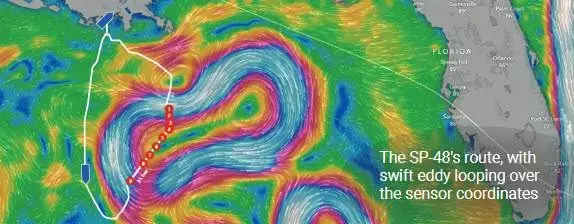
The SP-48 was deployed from the Louisiana Universities Marine Consortium (LUMCON) in Cocodrie, La., and piloted remotely from SeaTrac’s operations center in Marblehead, Mass. The USV covered over 580 nautical miles, acoustically harvesting data from the sensors and relaying it to onshore researchers.
Navigating the Gulf of Mexico’s Challenging Conditions
The U.S. Gulf of Mexico presents harsh challenges due to strong currents, fast-moving eddies, and unpredictable sea states. During this mission, an eddy formed atop the sensor locations, making navigation and station-keeping a complex task. SeaTrac’s Dashboard software enabled dynamic and precise mission planning to navigate through eddy currents.
Benefits of Using USVs for Data Collection
The use of SeaTrac’s uncrewed surface vehicle and Sonardyne’s payload technology offers several benefits:
- Reduced operational costs.
- Elimination of risks to human crews.
- Lower carbon emissions.
- Improved data collection efficiency.
Conclusion
The collaboration between SeaTrac and Sonardyne in the Gulf of Mexico marks a pivotal moment in marine robotics and oceanographic data collection. The use of USVs equipped with advanced acoustic technology offers a safer, more efficient, and sustainable approach to gathering critical data for various maritime applications. As the project continues through the summer of 2025, the insights gained will be invaluable for informing decision-making in offshore energy development, fisheries management, and other ocean interests.
Sources:


Leave a Reply